Current Weather @ 5:40 PM overcast - light rain Temp 39.5º Humidity 91% Winds SSW 2.0mph Max Gust 21.0mph
Todays Extremes High 48.7º Low 39.4º Rain 0.70" Rain Rate 0.038" per hr Snow 0.00" Season 0"
ALERTS (click alert for more info)

(Click alert for more info)
Welcome
Username:

Password:


Remember me

[ ]
[ ]
SUPPORT SCM!
Support SCM by making a single or recurring donation.


ROADS AND TRAFFIC
Updated: 05:30 PM v2.5
Run Spr to Highland  (330): 22 mins  
Highland to Run Spr  (330): 22 mins  
Big Bear to Run Spr    (18): 23 mins  
Run Spr to Big Bear    (18): 24 mins  
Big Bear to Redlands  (38): CLOSED   
Redlands to Big Bear  (38): CLOSED   
Big Bear to Lucerne    (18): 34 mins  
Lucerne to Big Bear    (18): 35 mins  
=Light  =Moderate  =Heavy Traffic
Road Conditions Page: Click Here
Online
Guests: 343, Members: 11 ...
Applenut
Getoutdoors
WestyN
Tman
Porlalee
Peanut
Sizzilean
Dionne Big Bear

most ever online: 3772
(Members: 27, Guests: 3745) on Feb 26 23: 07:51am

Members: 9476
Newest member: ErinPaige
Member's Birthdays:
Happy Birthday to:

Birthday Cake
RSKaren


Upcoming Birthdays:
Nov 16 bigbearjen
Nov 17 Silver
Nov 18 LB BIG BEAR
Nov 19 RichardG
Nov 19 Cap'n Crunch
Nov 19 Brocky
LATEST INCIDENTS (DETAIL)


NO MAP IS AVAILABLE NOT ENOUGH INFORMATION

SAT NOV 15, 2025, 2:45 PM
ACCIDENT NO INJURIES
RUNNING SPRINGS
3800 BLOCK OF HIGHWAY 330 N SBD 38.10
3:27PM [22] MESSAGE DELIVERED TO DONS FOR ESTIMATED TIME OF ARRIVAL ---30 MINS [SHARED]
3:09PM [17] LARGE ROCK IN LANES [SHARED]
3:08PM [12] [NOTIFICATION] [CHP]-DUPE ADVISE TRAFFIC HAZARD UPBOUND LANES [SHARED]
2:41PM [7] REPORTING PARTY REQUEST TRIPLE A TOW TRUCK REQUIRED FB
2:40PM [6] ROCK FELL OFF MOUNTAIN AND HIT VEHICLE

UNITS RESPONDING: CHP (CHP)
NOTES:
TRAFFIC ACCIDENT WITH PROPERTY DAMAGE COLLISION-NO INJURY 3810 HIGHWAY 330 N SBD 38.10
**ALERT** REPORTED ROCKS IN ROADWAY
WEATHER AT INCIDENT LOCATION: 47 DEGREES WITH 93% HUMIDITY. WINDS SSW AT 5 MPH. PRECIP: RAINING
(SOCALMOUNTAINS.COM CAD v13.1)


PHOTOS & MAPS:  

SCM Incident Map
Incident Street View
SCM Incident Map
Incident Satellite Map


INCIDENT UPDATES: 0   


SCANNER AUDIO IS NOT AVAILABLE FROM THIS HOUR


Chatbox
You must be logged in to post comments on this site - please either log in or if you are not registered click here to signup


Applenut
4 minute(s) ago
Lots and lots of rocks on the road at Arctic Circle, kudos to the car full of young women ahead of me that bailed out in the rain and pushed the bigger rocks off to the side so traffic could pass.

SCM ALERT🚨
6 minute(s) ago
SNOWING on the SCM Live Cam at the top of Bear Mountain!
Web Cams Page: [Click Here]

SCM ALERT🚨
44 minute(s) ago
[CHP DISPATCH] RUNNING SPRINGS - SLIDE ON ROADWAY HIGHWAY 18 / PALI MOUNTAIN
UPDATES: [Click Here]

doo·hick·ey
1 hour(s) ago
Is the power off near Wyatt’s (bb city)?

SCM ALERT🚨
2 hour(s) ago
[CHP DISPATCH] RUNNING SPRINGS - SLIDE ON ROADWAY HIGHWAY 18 / LAKEVIEW POINT
UPDATES: [Click Here]

SCM ALERT🚨
3 hour(s) ago
This is station one, go ahead. Valley of the Falls Drive is going to be closed from Canyon to the end due to mud and debris. No access at this time. [MUD]
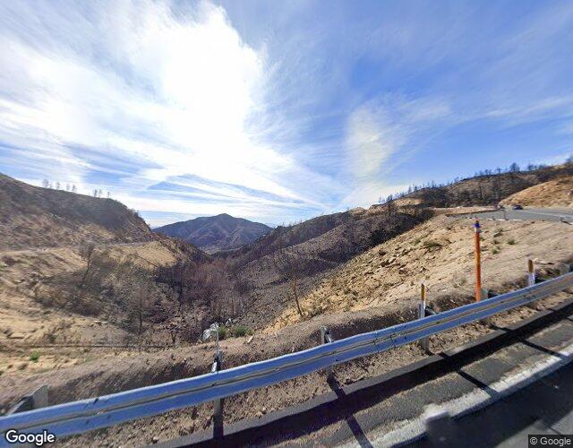
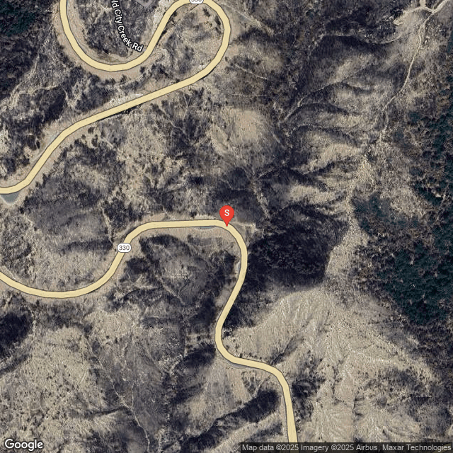

SCM ALERT🚨
3 hour(s) ago
[CHP DISPATCH] CRESTLINE - SLIDE ON ROADWAY SR138 / HIGHWAY 18
UPDATES: [Click Here]

SCM ALERT🚨
3 hour(s) ago
[INCIDENT DISPATCH]
VEH OVER THE SIDE in HIGHLAND
POSSIBLE TC OVER THE SIDE, SOUTHBOUND HIGHWAY 330, SOUTH OF HIGHLAND AVENUE, RESPOND ON 2TAC2, CONTACT BATTALION 141.
Map, Photos, More Info: [Click Here]

SCM ALERT🚨
3 hour(s) ago
[CHP DISPATCH] SAN BERNARDINO - REPORTED FIRE HIGHWAY 330 N NO / HIGHLAND AVE
UPDATES: [Click Here]

SCM ALERT🚨
4 hour(s) ago
CHP DISPATCH
Highway 18 Arctic Circle. Rocks in Roadway. 5 to 10 LB boulders in both Up and Downbound lanes.

SCM ALERT🚨
4 hour(s) ago
SLIDE ON ROADWAY
CRESTLINE
HIGHWAY 18 at CRESTLINE BRIDGE
1:24PM [5] 10 PARTYS OUT OF VEHICLES TRYING TO MOVE BOULDERS
1:23PM [3] ROCK SLIDE - LARGE BOULDERS IN UPBOUND AND DOWNBOUND LANES

CreakyTree
5 hour(s) ago
Trua, I've noticed that lately as well. I think people have just gotten too used to having automatic headlights now that they don't even think about turning them on themselves.

SCM ALERT🚨
5 hour(s) ago
Oak Glen Road is now also closed up to Potato Canyon Road due to mud and debris flow.

SCM ALERT🚨
5 hour(s) ago
Potato Canyon Road is closed in Oak Glen, from Oak Glen Road to Oak Glen Road, due to flooding and debris.

Van
5 hour(s) ago
1.19" of rain so far and the temp has dropped to 39. We're getting there!


Latest Forum Posts
Posted by doo·hick·ey in WEATHER DISCUSSION
…(oops meaning 46 and 83 still available) (Nov 15 25: 04:26pm)

Posted by doo·hick·ey in WEATHER DISCUSSION
46-83 are all taken (Nov 15 25: 04:20pm)

Posted by ROCK in WEATHER DISCUSSION
65 (Nov 14 25: 07:38am)

Posted by Polar 🌌rbit in WEATHER DISCUSSION
42 (Nov 14 25: 05:37am)

Posted by SDGrandma in WEATHER DISCUSSION
82 please (Nov 12 25: 06:26pm)

Posted by Hollis in WEATHER DISCUSSION
90 please (Nov 10 25: 11:05pm)

Posted by SCM ALERT🚨 in ROAD CONDITIONS
CALTRANS UPDATE: SBCO: Heads up! 🚗If youre driving on SR138 between Cajon Pass (Nov 10 25: 02:59pm)

Posted by ⚡WX ALERT⚡ in WEATHER DISCUSSION
Great job thus far everyone!!! So date, we have 50 entries! This is a first come (Nov 10 25: 01:16pm)


(C)2002-2025 Socalmountains.com
All Rights Reserved
Privacy Policy Terms of Service
Contact Us

{THEMEDISCLAIMER}